Category:
NewsNepal Flood Exposes Critical Gaps in Bhutan's Early Warning Systems
A Himalayan Wake-Up Call 🌄
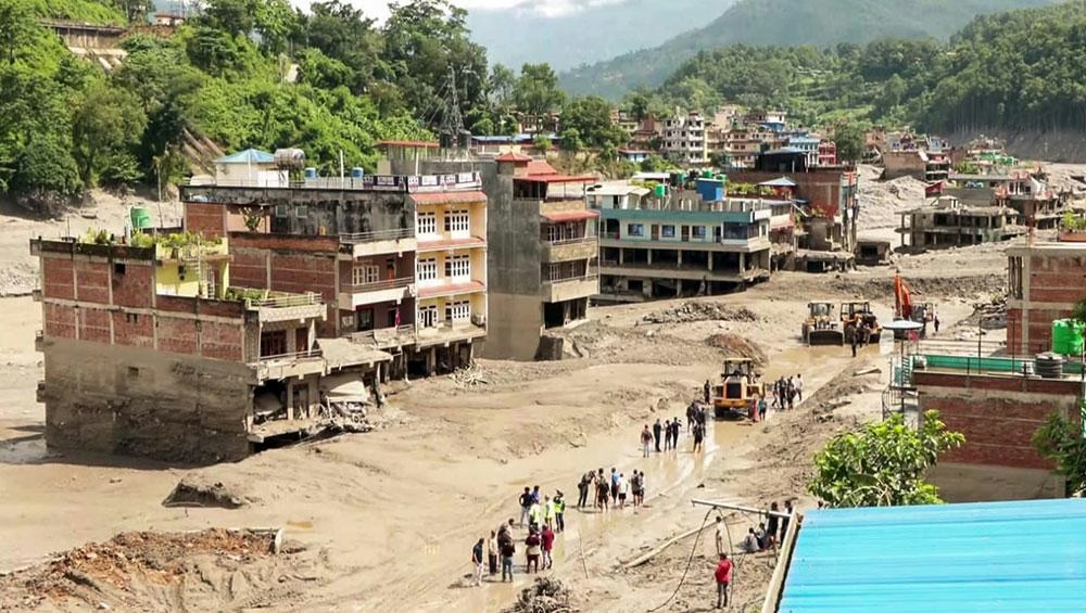
When a catastrophic flood devastated communities along the Nepal-Tibet border in late August, it sent shockwaves far beyond the immediate disaster zone. The collapse of glacier ice and rock that triggered the disaster revealed a sobering truth: mountain floods can strike with devastating force in areas where it hasn't rained, devastating communities with little warning. For Bhutan, nestled in the same Himalayan range, this incident serves as a critical reminder of the vulnerabilities embedded in the kingdom's early warning infrastructure.
The Nepal disaster claimed over 547 lives, with more than 1,500 people reported missing as of late August. Yet what made this particular catastrophe especially instructive for regional preparedness was not just its scale, but the mechanism behind it—a mechanism that could easily replicate itself in Bhutan's high-altitude valleys.
The Mechanics of Mountain Floods 🏔️
Understanding how these floods develop is essential to grasping why traditional weather forecasting falls short. When massive blocks of glacial ice or rock collapse into a valley, they don't require local rainfall to generate catastrophic flooding. Instead, the debris and displaced water surge downstream with tremendous force, creating a wall of destruction that catches communities off guard.
In the Nepal incident, debris temporarily blocked the Lhende River, causing water and sediment to surge downstream with devastating velocity. Preliminary investigations revealed that affected locations experienced dry conditions—yet floodwaters reached them anyway. This disconnect between local weather and flood occurrence represents a fundamental challenge for early warning systems designed primarily around precipitation forecasting.
Bhutan's vulnerability mirrors Nepal's in several critical ways:
- Both nations occupy steep Himalayan terrain with high-altitude glacial lakes
- Remote valleys have limited connectivity for real-time monitoring
- Automatic sensors can be destroyed by the very floods they're designed to detect
- Communities often lack sufficient warning time to evacuate safely
Bhutan's Recent Brush with Disaster ⚠️
Bhutan has already experienced the precarious nature of glacial lake flooding firsthand. On October 30, 2023, Thorthormi Lake in the remote Lunana region partially breached, releasing approximately 1.98 million cubic meters of water downstream. The incident caused significant damage to monitoring infrastructure and destroyed a footbridge, but fortunately resulted in no reported deaths.
What happened at Thorthormi reveals the fragility of current systems. The automatic water-level station that should have detected the breach was itself damaged by the flood. The exact trigger remains under investigation, though researchers consider ice movement and glacier disintegration as probable causes.
Following the 2023 incident, the National Centre for Hydrology and Meteorology (NCHM) recommended urgent improvements: additional sensors, enhanced warning protocols, precise lake-depth measurements, and relocation of households facing dangerously short evacuation windows. These recommendations underscore how the 2023 event exposed systemic weaknesses.
When Sirens Fail: The Human Element 📢
Research examining both the 2019 and 2023 Thorthormi incidents revealed a troubling pattern. Residents primarily relied on environmental signals—unusual sounds, changes in water behavior—and word-of-mouth warnings from friends and relatives. Formal warning systems proved inadequate or failed entirely.
The 2019 flood remained below the threshold that would trigger alarm sirens. The 2023 event destroyed the very sensors meant to activate warnings. This creates a vicious cycle: the most dangerous floods are those that overwhelm existing infrastructure, leaving communities dependent on informal communication networks that may not reach everyone in time.
A 2026 study of these incidents concluded that effective warnings require more than equipment alone. Detection systems must function, instruments must survive the initial surge, and information must reach people with sufficient time to evacuate. When any element fails, the entire chain breaks down.
Nepal's Experience: A Cautionary Tale 🚨
Nepal's disaster in August provided a real-time case study of these failures. The nation maintained monitoring stations and warning protocols—yet they proved insufficient when tested against an actual catastrophe.
The Bhotekoshi-Syafrubesi monitoring station stopped transmitting at 8:50 AM. Its final reading, recorded ten minutes earlier, showed water levels below the official warning threshold. Officials received flood reports at 9:00 AM, with mass SMS warnings following at approximately 9:15-9:16 AM.
The system ultimately sent 679,295 SMS alerts and is credited with saving lives. However, four monitoring stations were completely washed away by the flood. Communities nearest the disaster source experienced flooding before any alert could reach them, while downstream populations benefited from the warning window.
This sequence illustrates a critical principle: early warning systems can only protect populations that have both time and information to act. Those closest to the source often receive neither.
Bhutan's Current Monitoring Capacity 🛰️
Bhutan's early warning infrastructure exists but remains incomplete and unevenly distributed. The NCHM operates dedicated systems in three major river basins: Punatsangchhu, Mangdechhu, and Chamkhar Chhu. The agency aims to eventually extend coverage across all river basins, but significant gaps remain.
The Punatsangchhu and Mangdechhu systems rely primarily on satellite links for data transmission, while other systems use mobile networks. This dual approach creates vulnerabilities: satellite systems can be affected by atmospheric conditions, while mobile networks provide limited coverage in deep valleys and high-altitude areas.
Connectivity challenges particularly affect Lunana, where potentially dangerous glacial lakes exist. While some downstream areas maintain adequate mobile signals, the lakes and glaciers themselves often lack reliable transmission capability. An official from NCHM acknowledged this gap: "We are in the Himalayas, so the type of flood that happened in Nepal could also happen in Bhutan due to our topography and geography. But where and how it will happen is the question, and we do not know."
The Climate Change Factor 🌡️
Bhutan's glacial landscape is changing at an accelerating pace, increasing flood risk independent of immediate weather conditions. The Hindu Kush Himalaya region, which includes both Bhutan and Nepal, warmed by approximately 0.28°C per decade between 1951 and 2020—nearly double the global average.
This warming has triggered dramatic changes in glacial systems. Glacier mass loss in the region accelerated by roughly 65 percent when comparing different decades of study. For Bhutan specifically, the 2026 Glacier Inventory documented 673 glaciers covering 571.86 square kilometers, compared to 700 glaciers covering 629.55 square kilometers in the previous inventory. This represents a 9.16 percent decline in glacial area over just nine years.
Simultaneously, glacial lakes are multiplying. The latest glacial lake inventory records 620 lakes, up from 567 in 2021. Their mapped area increased from approximately 55.04 to 58.18 square kilometers. More lakes mean more potential for catastrophic breaches, particularly as climate-driven instability affects surrounding slopes and ice masses.
NCHM currently identifies 17 potentially dangerous glacial lakes, down from 25 previously. However, this reduction doesn't necessarily indicate decreased risk. The classification depends on multiple factors beyond just the lake itself: surrounding slope stability, barrier integrity, outlet conditions, avalanche paths, and proximity to downstream settlements all influence actual hazard levels.
Beyond Weather Forecasting 🔍
Bhutan's NCHM updates weather forecasts four times daily, providing valuable information for identifying rainfall-related hazards. However, this capability cannot predict when a glacier will collapse or when a mountainside will fail.
The triggers for these catastrophic events remain partially mysterious. Ice or rock can fall into a lake, displacing water over its barrier. Landslides can block rivers, creating temporary reservoirs that eventually fail. Glacier retreat and thawing permafrost contribute to instability, though the specific mechanisms vary between locations. Researchers continue investigating what precise role climate change played in the August Nepal disaster.
This uncertainty creates a fundamental challenge: predictive capacity has limits. No forecasting model can reliably predict exactly when and where a glacier will collapse. Early warning systems must therefore focus on rapid detection and response rather than prediction.
The Infrastructure Gap 🏗️
The distance between having sensors and ensuring community safety remains dangerously wide. Bhutan's NCHM has made progress establishing monitoring networks, but coverage remains incomplete and vulnerable.
Limited connectivity in high-altitude areas prevents real-time data transmission from remote glacial lakes. Deep valleys create signal dead zones where mobile networks cannot reach. Satellite systems, while more reliable in remote areas, face their own limitations during adverse weather conditions.
An NCHM official noted that parts of Lunana downstream of critical lakes maintain adequate connectivity, but extending coverage across the lakes and glaciers themselves would significantly improve monitoring capacity. This expansion remains a priority but faces technical and logistical challenges inherent to Bhutan's mountainous terrain.
Lessons for Regional Preparedness 📚
Nepal's experience and Bhutan's own recent incidents point toward several critical improvements needed across the Himalayan region:
Redundant Monitoring Systems: Relying on a single monitoring station creates catastrophic vulnerability. Multiple sensors at different elevations could provide backup if one is destroyed.
Improved Connectivity Infrastructure: Expanding satellite and mobile coverage into remote glacial areas should be a regional priority, not merely a national one.
Community-Based Warning Networks: Formal systems must be complemented by trained community networks capable of spreading warnings through informal channels when technology fails.
Rapid Response Protocols: Clear evacuation procedures and pre-positioned emergency resources can minimize casualties even when warning time is limited.
Cross-Border Coordination: Given that glacial lakes and rivers cross national boundaries, Nepal and Bhutan should establish joint monitoring and alert protocols.
Looking Forward: Strengthening Defenses 💪
Bhutan faces a complex challenge requiring sustained investment and regional cooperation. The kingdom's NCHM has identified necessary improvements following the 2023 Thorthormi incident, including enhanced sensor networks, improved warning protocols, and household relocation programs for high-risk areas.
However, implementing these recommendations requires resources, technical expertise, and political will. The Nepal disaster provides urgent justification for accelerating these efforts. Communities in Lunana and other high-altitude regions cannot wait for perfect solutions—they need functional systems now.
The broader lesson extends beyond Bhutan. The entire Himalayan region faces increasing glacial hazard risk as climate change accelerates. Early warning systems represent just one component of comprehensive disaster risk reduction. Equally important are land-use planning that keeps communities away from hazardous areas, infrastructure designed to withstand floods, and regional cooperation frameworks that share data and best practices.
Bhutan's experience demonstrates both the possibilities and limitations of technological solutions. Sensors and satellites matter, but they cannot replace human judgment, community preparedness, and political commitment to risk reduction. The Nepal flood serves as a stark reminder that in the Himalayas, complacency can be fatal. The time to strengthen defenses is now, before the next disaster strikes. 🛡️
You May Also Like
News
Women Entrepreneurs Master AI and Digital Tools in Phuentsholing
September 1, 2026
News
Can Samtse Keep Up With Its Growing Workforce?
August 29, 2026
News
High Court Overturns Acquittal: Doctor Sentenced to 10 Years for Child Sexual Abuse
August 29, 2026
News
Bhutan's Critical Engineer Shortage Threatens Megaproject Timeline
August 29, 2026